There are 49 days of counting between Pesach and Shavuos, the period known as S’firas HaOmer. There are 50 states in the union. Following up on the popularity of our Chol HaMoed travel guide and my other job teaching American history at Touro College, I am sharing this guide, which combines Jewish observance with Americana.

Delaware is the first state. We counted Omer 1 two days ago during Yom Tov, on the evening of April 6. Delaware ratified the Constitution on December 1, 1787. Its route marker is a white circle on a black square. Route 1 runs the length of the state for 102 miles, from Fenwick Island on the Maryland border, north to Christiana on the border of Pennsylvania.

We counted Omer 2 during Yom Tov on the evening of April 7. Pennsylvania ratified the Constitution on December 12, 1787. Route 2 ran for 163 miles from Philadelphia to Great Bend. It was decommissioned in 1928, less than a decade after its designation. The logo of Pennsylvania’s routes is a keystone, the symbol of the state.

We counted Omer 3 on the evening of April 8. New Jersey ratified the United States Constitution on December 18, 1787. Route 3 runs from Clifton to North Bergen. The logo is nearly identical to that of Delaware.

We counted Omer 4 on the evening of April 9. Georgia ratified the US Constitution on January 2, 1788. Route 4 runs for 217 miles from the border of South Carolina to the border of Florida. The logo is an outline of the state on a map, in the same colors as the previously listed states.

We counted Omer 5 on the evening of April 10. Connecticut ratified the Constitution on January 9, 1788. This one is a trick: There is no Route 5 on the state’s list of roads. That number is designated for US Route 5, which runs from New Haven to the Massachusetts state line at Longmeadow. The logo for Connecticut’s routes is a simple white square with a thin black border.

We counted Omer 6 on the evening of April 11. Massachusetts ratified the Constitution on February 6, 1788. This one is also a trick: There is no Route 6 on the state’s list of roads. That number is designated for US Route 6, which runs for 118 miles from the tip of Cape Cod to the Rhode Island state line. The logo for Massachusetts’ routes is the same as for Connecticut.

We counted Omer 7 on the evening of April 12. Maryland ratified the Constitution on April 28, 1788. This route runs in three disconnected segments between Baltimore and Elkton. The logo for Maryland’s routes informs travelers of their presence in the state.

We counted Omer 8 on the evening of April 13. South Carolina ratified the Constitution on May 23, 1788. This route runs for 44 miles in Greenville, Pickens, and Anderson counties. The logo for South Carolina’s routes is dark blue with the palmetto tree in the map outline of the state.

We counted Omer 9 on the evening of April 14. New Hampshire ratified the Constitution on June 21, 1788. This route runs for 110 miles from the border of Maine to the border of Vermont. The logo for New Hampshire’s routes is an outline of the Old Man of the Mountain, a natural rock formation that collapsed in 2003. It is preserved for posterity on the state route signs and its license plates.

We counted Omer 10 on the evening of April 15. Virginia ratified the Constitution on June 25, 1788. This route runs for 93 miles from Richmond to Suffolk. The logo for Virginia’s roads is a shield.

We counted Omer 11 on the evening of April 16. New York ratified the Constitution on July 26, 1788. As Route 11 only existed between 1924 and 1927 before being absorbed into longer numbered roads, here’s 11A. This route runs for 11 miles in Onondaga County. The logo is a silhouette of the state emblem, which also appears on the state flag.

We counted Omer 12 on the evening of April 17. North Carolina ratified the Constitution on November 25, 1789. This route runs for 148 miles on the Outer Banks barrier islands, connected by four bridges and two ferries on its storm-battered route. The logo is a white diamond on a black square.

We counted Omer 13 on the evening of April 18. Rhode Island ratified the Constitution on May 29, 1790, the last of the thirteen original states to do so. As the nation’s smallest state does not have Route 13, here’s the logo for 113. It runs for 3.4 miles near the city of Warwick. The logo is nearly identical to its neighbors, Connecticut and Massachusetts, with the state’s initials to set it apart.

We counted Omer 14 on the evening of April 19. Vermont ratified the Constitution on March 4, 1791, after 14 years of being an unrecognized independent republic. This route runs for 109 miles from White River Junction on the border of New Hampshire, north to Newport, within a few miles of the Canadian border. The logo’s color is in honor of the Green Mountains that give the state its name. Perhaps the barrel shape holding the number is for Vermont’s maple syrup industry.

We count Omer 15 on the evening of April 20. Kentucky ratified the Constitution on June 1, 1792, after it broke away from Virginia. This route runs for 131 miles from the bluegrass region to the coal mines of the Cumberland Plateau. The logo is identical to Delaware and New Jersey. Kentucky is far enough from those states to avoid any confusion for travelers.

We count Omer 16 on the evening of April 21. Tennessee ratified the Constitution on June 1, 1796, from the Southwest Territory and the unrecognized state of Franklin. This route runs for 77 miles from the Alabama state border north to Williamson County. The logo is nearly identical to some of the New England states, with the map outline of Tennessee to set it apart.

We count Omer 17 on the evening of April 22. Ohio ratified the Constitution on March 1, 1803, the state being formed from the old Northwest Territory. This route runs for 21 miles in a nearly straight line from Bedford Heights to North Olmsted, two towns to the south of Cleveland. The shape of the white area can be confused with New York, but it is the map outline of Ohio.

We count Omer 18 on the evening of April 23. Louisiana was admitted as a state on April 30, 1812, nearly a decade after France sold this land to the United States. This route runs for 93 miles on the right bank of the Mississippi River from Donaldsonville to Gretna. It is part of the Great River Road, a scenic byway that follows the river from its mouth to its source in Minnesota. The shape of the white area is the map outline of Louisiana with its postal abbreviation.

We count Omer 19 on the evening of April 24. Indiana was admitted as a state on December 11, 1816. This route runs for 143 miles between Noblesville and Elkhart on the border with Michigan. The logo is nearly identical to three states in New England, with the state’s name to set it apart.

We count Omer 20 on the evening of April 25. Mississippi was admitted as a state on December 10, 1817. Route 20 was renumbered as 28 in 1960 to avoid confusion with Interstate 20, which also runs east-west through the Magnolia State. The logo is identical to Delaware, New Jersey, and Kentucky. As the state adopted a new flag in 2021, perhaps it can hold a contest for a new state route shield.

We count Omer 21 on the evening of April 26. Illinois was admitted as a state on December 3, 1818. For its 28-mile run, Illinois Route 21 parallels the shore of Lake Michigan through Niles, Northbrook, and North Chicago. The logo is identical to its neighbor Indiana, with the state’s name to set it apart.

We count Omer 22 on the evening of April 27. Alabama was admitted as a state on December 14, 1819. State Route 22 runs for 168 miles from Safford in the heart of the state, going east to the border with Georgia. The logo uses the black and white of most state shields, with a compressed map outline of Alabama inside a square.

We count Omer 23 on the evening of April 28. Maine was admitted as a state on March 15, 1820, after it broke away from Massachusetts. State route 23 runs for 68 miles from Guildford to Sidney, a few miles shy of the capital city of Augusta. Four of the six New England states use the white box with a black border logo. Maine is among them.

We count Omer 24 on the evening of April 29. Missouri was admitted as a state on March 15, 1820, in the same year as Maine to preserve the balance of northern and southern states. As Missouri does not have a Route 24, with that number assigned to US Route 24, which runs through the state. Route 124 runs for 35 miles terminating in Centralia, in the heart of the state. The logo uses the black and white of most state shields, with a map outline of Missouri inside a square.

We count Omer 25 on the evening of April 30. Arkansas was admitted as a state on March 15, 1836, from land that was within the Louisiana Purchase of 1803. The pronunciation and spelling of its name is based on the French language. State Highway 25 runs in a northeast-southwest direction for 86 miles, from Black Rock to Conway. The logo uses the black and white of most state shields, with a map outline of Arkansas inside a square.

We count Omer 26 on the evening of May 1. Michigan was admitted as a state on January 26, 1837. State Highway 26 runs for 93 miles on the scenic Keweenaw Peninsula that juts into Lake Superior. The logo is similar to that of North Carolina’s roads, but for the sharp points on the diamond and the M for Michigan.
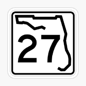
We count Omer 27 on the evening of May 2. Florida was admitted as a state on March 3, 1845, having purchased this peninsula from Spain in 1821. US Route 27 runs the length of the state for nearly 500 miles from Miami to the Georgia border. Florida’s DOT omitted 27 from its list of state routes. I made up the shield with Florida’s design. It contains the route number with the map outline of the state inside a white square.
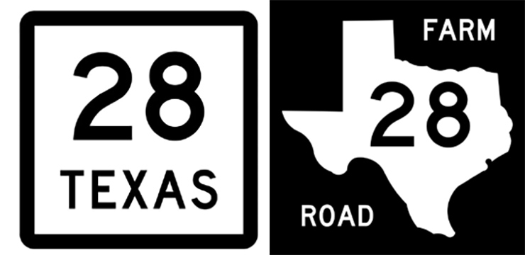
We count Omer 28 on the evening of May 3. Texas was admitted as a state on December 19, 1845, nine years after its white settlers seceded from Mexico and declared Texas an independent republic. State Highway 28 is a phantom on the map of Texas. Its route was absorbed in the 1930s into State Highways 25, 51, and 183. Initially, the logo for state routes in Texas involved a star with a number inside it, fitting with the Texan identity as the Lone Star State. But at some point, the uninspiring framed square became the official shield of the state’s roads. A second category of state-run routes are Farm-to-Market roads, which have the map outline of the state inside it. FM 28 runs for 29 miles in Crosby and Floyd Counties.

We count Omer 29 on the evening of May 4. Iowa was admitted as a state on December 28, 1846, from land that was within the Louisiana Purchase. State Highway 29 was decommissioned in 1957 to avoid confusion with Interstate 29, which runs across Iowa. The shield for this state is the same design as Delaware, New Jersey, and Mississippi.

We count Omer 30 on the evening of May 5. Wisconsin was admitted as a state on May 29, 1848. State Highway 30 is very short, running for 3.43 miles near Madison, where it connects Interstates 39, 90, and 94. The shield appears to be a square and a triangle with a number on top of it.
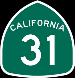
We count Omer 31 on the evening of May 6. California was admitted as a state on September 9, 1850, much earlier than other western states. Its statehood was the result of a rapid population boom that followed the discovery of gold two years earlier. State Route 31 ran between Corona and Debore Heights, near San Bernardino. The number was decommissioned in 1974 when this route was absorbed into Interstate 15. The shield is inspired by a gold miner’s spade.

We count Omer 32 on the evening of May 7. Minnesota was admitted as a state on May 11, 1858. State Highway 32 runs as a north-south straight line for 145 miles from Greenbush to Barnesville. The “Land of 10,000 Lakes” fittingly has the blue color as the backdrop behind the route number. Atop this square is a yellow border with a map outline of the state and its name.

We count Omer 33 on the evening of May 8. Oregon was admitted as a state on February 14, 1859. The 49 miles of State Highway 33 was absorbed into US Route 20, between Corvallis and Newport. As it is not posted, here is the sign for Route 233, which runs for ten miles from Amity to Dayton in a northeast-southwest direction. The logo has the appearance of a rounded shield.

Oregon had the honor of Lag BaOmer this year, but the festivities usually extend into 34, which is on the evening of May 9. Kansas was admitted as a state on January 29, 1861. Route K-34 runs north-south for 29 miles in the southeast of this state. The state route shield has the fiery brightness of the previous day and evokes the sunflower, a symbol of the state.

We count Omer 35 on the evening of May 10. West Virginia was admitted as a state on June 20, 1863, after it broke away from Virginia. State Route 35 was discontinued in 1938 and absorbed into State Route 5. The logo is nearly identical to that of Connecticut’s state routes, albeit with a thicker border.
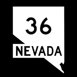
We count Omer 36 on the night of May 11. Nevada was admitted as a state on October 31, 1864. State Route 36 ran through Carson City, the state capital, until 1976, when it was renumbered as State Route 518. The logo is a map outline of the state with its name and the route number.

We count Omer 37 on the night of May 12. Nebraska was admitted as a state on March 1, 1867. State Route 27 was decommissioned in 1925, four years after it was put on the map. State Highway 137 runs for nearly 30 miles in the north of the state, a sparsely populated area. The logo has the Conestoga wagon, which brought pioneering settlers to the Great Plains in the mid-19th century.

We count Omer 38 on the evening of May 13. Colorado was admitted as a state on August 1, 1876. State Route 38 was decommissioned in 2007. It marked West Fillmore Street in Colorado Springs. The logo has Colorado’s state flag on it, among the most recognizable in the union.
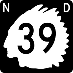
We count Omer 39 on the evening of May 14. North Dakota was admitted as a state on November 2, 1889. State Highway 39 was renumbered as 256 in 1975. The logo used to be the silhouette of Marcellus Red Tomahawk (1849-1941), a Lakota Native police officer. In 2016, the state DOT instituted a new highway shield that is more in line with most states: a map outline of North Dakota on a black background.

We count Omer 40 on the evening of May 15. South Dakota was admitted as a state on the same day as North Dakota. State Highway 40 runs for 37 miles in the southeastern corner of this state. The logo is a map outline of the state inside a dark green square.
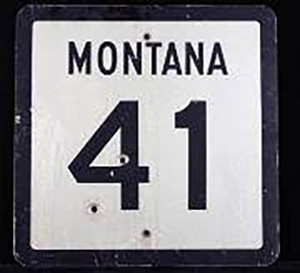
We count Omer 41 on the evening of May 16. Montana was admitted as a state on November 8, 1889. State Highway 41 runs for 51 miles in the southeast corner of this state. The state highway shield is identical to that of West Virginia and Connecticut, among other states.

We count Omer 42 on the evening of May 17. Washington was admitted as a state on November 11, 1889. Route 41 is missing from the roster. State Route 142 runs for 35 miles in the south of this state. The logo is a profile of President George Washington, the namesake of this Pacific Northwest state.
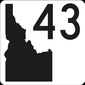
We count Omer 43 on the evening of May 18. Idaho was admitted as a state on July 3, 1890. State Highway 43 runs for nearly four miles in Bonneville County. The logo is a map outline of the state. In contrast to most such logos, the state’s logo is black on a white background.

We count Omer 44 on the evening of May 19. Wyoming was admitted as a state on July 10, 1890. 44 was never assigned to the roster of state highways. The nearest route number is 37, which runs for nine miles into the Bighorn Canyon National Recreation Area. The shield is a yellow square with the state’s name and a small silhouette of a cowboy atop a horse.

We count Omer 45 on the evening of May 20. Utah was admitted as a state on January 4, 1896. State Route 45 runs for 40 miles in the northeast of the state to a town named Bonanza. The logo is a beehive with the route number. The beehive is a symbol of industry, and it also appears on the flag and seal of Utah.

We count Omer 46 on the evening of May 21. Oklahoma was admitted as a state on November 16, 1907, the first state to do so in the 20th century. State Highway 46 runs for 49 miles near the point where the mainland of this state meets its famous panhandle. The logo is a map outline of the state, white on white, with the route number.

We count Omer 47 on the evening of May 22. New Mexico was admitted as a state on January 6, 1912. State Road 47 begins in Albuquerque and runs south for 60 miles to US Route 60 in Socorro County. The logo is inspired by the red-sun symbol of the native Zia people. This symbol also appears on the state flag.
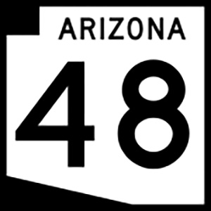
We count Omer 48 on the evening of May 23. Arizona was admitted as a state on February 14, 1912. State Road 48 covers Fain Road, a 7.3-mile bypass around the town of Prescott Valley. It is an unsigned road, meaning that there are no signs on this route bearing the state route logo, a map outline of Arizona on a black background.
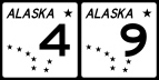
We count Omer 49 on the evening of May 24, and then we celebrate Shavuos. Alaska was admitted as a state on January 3, 1959, becoming the largest state in land area. It has only 12 numbered state routes, 1 through 11, and a special 98. The logo shows the Big Dipper constellation and Polaris, a combination that also appears on the state flag.

Not wishing to exclude our nation’s most recent state, here’s Hawaii. The former country was annexed in 1898 and was then admitted as a state on August 21, 1959. Route 50, also known as Kaumualiʻi Highway, runs for 33 miles on the south side of the island of Kauai. The logo has been compared to a spade, a guitar pick, a teardrop, and a raindrop. The state DOT website has no explanation for its origin.